


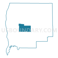
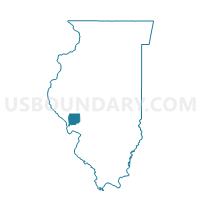
CARROLLTON II Voting District, Greene County, Illinois
About
Outline

Summary
| Unique Area Identifier | 571002 |
| Name | CARROLLTON II Voting District |
| County | Greene County |
| State | Illinois |
| Area (square miles) | 21.47 |
| Land Area (square miles) | 21.42 |
| Water Area (square miles) | 0.05 |
| % of Land Area | 99.77 |
| % of Water Area | 0.23 |
| Latitude of the Internal Point | 39.32954710 |
| Longtitude of the Internal Point | -90.43625660 |
Maps

Graphs
Select a template below for downloading or customizing gragh for CARROLLTON II Voting District, Greene County, Illinois


Neighbors
Neighoring Voting District (by Name) Neighboring Voting District on the Map
- BLUFFDALE Voting District, Greene County, IL
- CARROLLTON I Voting District, Greene County, IL
- CARROLLTON III Voting District, Greene County, IL
- CARROLLTON IV Voting District, Greene County, IL
- LINDER Voting District, Greene County, IL
- WALKERVILLE Voting District, Greene County, IL
- WHITE HALL III Voting District, Greene County, IL
- WRIGHTS Voting District, Greene County, IL
Top 10 Neighboring County Subdivision (by Population) Neighboring County Subdivision on the Map
- White Hall township, Greene County, IL (3,040)
- Carrollton township, Greene County, IL (2,966)
- Bluffdale township, Greene County, IL (556)
- Linder township, Greene County, IL (345)
- Wrights township, Greene County, IL (314)
- Walkerville township, Greene County, IL (233)
Top 10 Neighboring Place (by Population) Neighboring Place on the Map
Top 10 Neighboring Unified School District (by Population) Neighboring Unified School District on the Map
- North Greene Unit School District 3, IL (6,263)
- Carrollton Community Unit School District 1, IL (4,286)